SOUTHWESTERN USA RS ROAD TRIP
September 1, 2017 (Day 25)
Kanab, UT to Green River, UT
Miles Today: 287 / Total Trip Miles: 3,681
TODAY'S ROUTE
(Click on Map to Enlarge)
Our route to Green River took us through the Red Canyon of Dixie National Forest, the northern section of Grand Staircase-Escalante National Monument, a tiny part of Capitol Reef National Park, and badlands. Today's temperatures reached 93 degrees Fahrenheit. Highest elevation was 9,600 feet. Glimpses of Grand Staircase-Escalante National Monument and Capitol Reef National Park trigger our desire to return for a longer visit.
PHOTOS
(Click on Photo for a Larger Image)
Parry Lodge
Parry Lodge is a historic motel-restaurant located in Kanab. The main building was built in 1892. Over time, a barn, bungalow and other buildings were erected on the property. During 1930-1931 it was turned into a motel-restaurant complex. The buildings were designed in the American Craftsman and Victorian Eclectic styles. The complex has been listed on the National Register of Historic Places since 2003.
At the heart of the Parry Lodge is the Old Barn Theater, a rustic western theater that was formerly a barn in the old days of filming. The theater has showings, free of charge to guests, of films that were shot in the Kanab area. Over the years, Kanab was host to such popular television shows such as Gunsmoke, Death Valley Days, Lassie, and The Lone Ranger. As far as motion pictures, Wagon Train, Drums Along the Mohawk, Planet of the Apes, Arabian Nights, and My Friend Flicka were all filmed in or around Kanab.
DIXIE NATIONAL FOREST - RED CANYON:
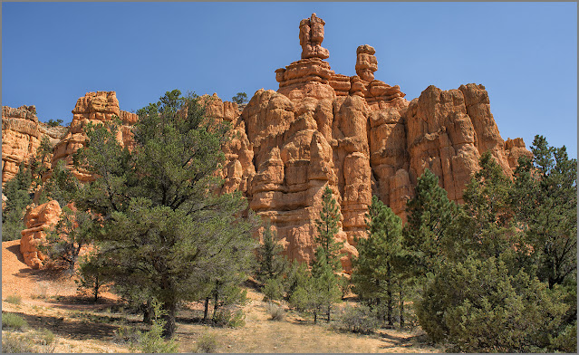
The brilliant red soil of Red Canyon provides a gorgeous contrast with the green pines of Dixie National Forest. The canyon features red sandstone hoodoos, spires and rock formations similar to that of Bryce National Park, but without the crowds. The Forest Service calls this "the most photographed place in Utah." Dixie National Forest occupies almost 2 million acres between the Great Basin and the Colorado River, making it the largest national forest in the state of Utah. High altitudes ranging from 2,800 feet to 11,300 feet give this forest an abundance of climates. Summer temperatures can reach 100 degrees Fahrenheit, while winters can see 40 inches of rain and minus-30 degrees Fahrenheit on the mountain plateaus.
Contrasting Red & Grey Sandstone
Thistles
Red Canyon features red sandstone hoodoos, spires and rock formations. Naturally shaped by wind and water, hoodoos (also known as fairy chimneys) have been carved over millions of years into pillar-like shapes.
GRAND STAIRCASE-ESCALANTE
NATIONAL MONUMENT:
Grand Staircase-Escalante National Monument spans across nearly one million acres of America's public lands. "The Grand Staircase" is an immense sequence of sedimentary rock layers that stretch south from Bryce Canyon National Park and Grand Staircase-Escalante National Monument, through Zion National Park, and into the Grand Canyon National Park. The Monument is a diverse geologic treasure speckled with monoliths, slot canyons, natural bridges, and arches. Due to its remote location and rugged landscape, the monument was one of the last places in the continental United States to be mapped.
The Monument’s size, resources, and remote character provide extraordinary opportunities for geologists, paleontologists, archeologists, historians, and biologists in scientific research, education, and exploration. This unspoiled natural area was a frontier with countless opportunities for quiet recreation and solitude.
The Rest Of The Story:
In February 2020, more than two years after carrying out the largest reversal of national monument protections in U.S. history, the Donald Trump administration finalized plans for the roughly 2 million acres of formerly protected land in southern Utah. The federal Bureau of Land Management released its plans to open up the lands, which were once protected as part of the Bears Ears and Grand Staircase-Escalante monuments, to use by energy developers and ranchers.
Grand Staircase
This unspoiled wilderness (before Donald Trump) is located in the Grand Staircase-Escalante National Monument along Idaho Highway 12 between the towns of Ecalante and Boulder.
Red Rock
Red rock located in the Grand Staircase-Escalante National Monument along Idaho Highway 12 between the towns of Ecalante and Boulder.
CAPITOL REEF NATIONAL PARK:
Chimney Rock
Chimney Rock is a 6,420-foot elevation summit located in Capitol Reef National Park. This landmark, situated 2.5 miles northwest of the park's visitor center, towers over 300 feet above Highway 24.
Highway 24 cuts through red rock canyons, passing by cliffs in Capitol Reef National Park. High speed roads and beautiful scenery.
BADLANDS:
HANKSVILLE TO INTERSTATE HIGHWAY 70
The topography along the forty-mile drive is characterized by mud flats with sparse grass, slot-like ravines, occasional bushes and eroded orange-brown sandstone buttes and other rock formations. This remote section of highway begs to be driven flat-out.
Eroded Sandstone
This formation is located at Mile Marker 123 on Utah Highway 24, about 10 miles north of Hanksville.
Upper Blue Hills
Factory Butte (6,302-foot summit) is the most recognizable feature of a large area of stark, barren land known as the Upper Blue Hills. (Photo Location: Mile Marker 123 on Utah Highway 24)
___________________________________________________
TOMORROW
Mary and I will be heading homeward. First stop is American Fork, UT.
____________________________________________________
COPYRIGHT
These photographs are the property of Leon Jackson, and are protected by copyright laws. Photographs may not to be downloaded or reproduced in any way without the written permission of Leon Jackson. © 2017 Leon Jackson. All Rights Reserved.
_________________________________________________________________


1 comment:
Exceptionally beautiful photos, Leon. Color is amazing.
Post a Comment