GET-YUR-MOTOR-RUNNIN' ROAD TRIP
(Astoria - Santa Fe - Death Valley - Astoria)
October 31, 2013 (Day 17 of 44)
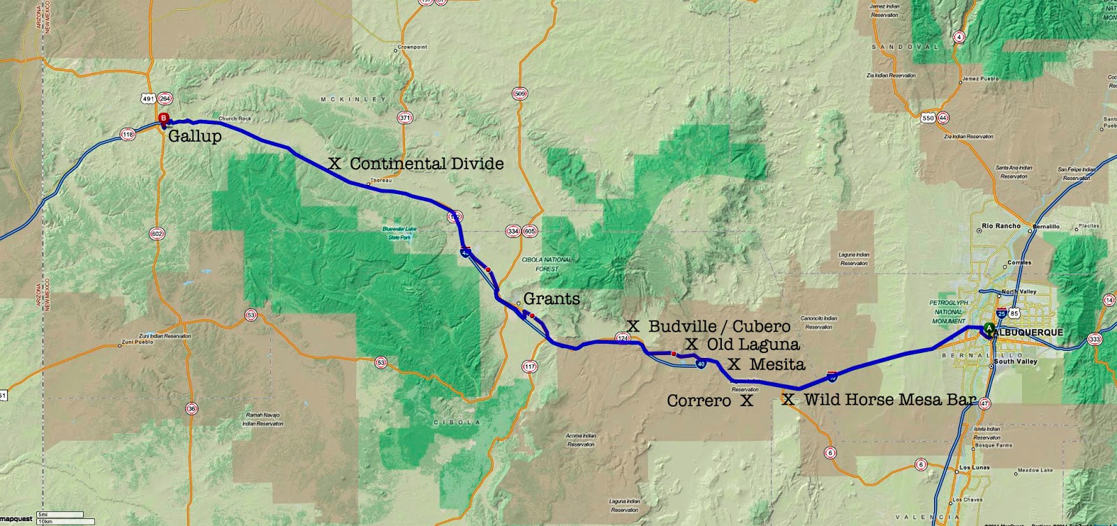
Albuquerque, NM to Gallup, NM
Miles Today: 140 / Trip Miles: 2,232
LYRICS TO "ROUTE 66"
(Composed in 1946 by Bobby Troup)
If you ever plan to motor west,
Travel my way, take the highway that is best.
Get your kicks on Route sixty-six.
It winds from Chicago to LA,
More than two thousand miles all the way.
Get your kicks on Route sixty-six.
Now you go through Saint Louie
Joplin, Missouri,
And Oklahoma City is mighty pretty.
You see Amarillo,
Gallup, New Mexico,
Flagstaff, Arizona.
Don't forget Winona,
Kingman, Barstow, San Bernandino.
Won't you get hip to this timely tip:
When you make that California trip
Get your kicks on Route sixty-six.
Won't you get hip to this timely tip:
When you make that California trip
Get your kicks on Route sixty-six.
Get your kicks on Route sixty-six.
Get your kicks on Route sixty-six.

Headed west along Central Avenue (Route 66). A slight breeze kept the air crystal clear, with a pale blue sky and a few clouds. Temperatures were comfortable, in the low- to mid-50s. A number of vintage motels have survived along the western section of Central Avenue: Western Ho, Adobe Manor and the Grand View motels. Central Avenue ends, and old Route 66 has been replaced with Interstate 40.
The terrain along I-40 becomes grassland and rolling hills with some mesas & plateaus in the distance. I-40 traffic was heavy with 18-wheelers slowly passing each other. I was eager to get on some backroads.
Old (Pre-1937) Section of Route 66:
I exited I-40 at the intersection with New Mexico Highway 6. Highway 6 is an older (pre-1937) alignment) of Route 66 that heads southeast to Los Lunas, and then north to Albuquerque. I took this alignment on my 2011 Route 66 Trip.
An old, abandoned roadhouse sits at the junction of NM-6 and an unmarked, poorly maintained section of old Route 66. I took some photos, and headed west to Mesita along this infrequently used section of Route 66. The road surface changed from paved to gravel, and then to non-maintained pavement with lots of huge pot holes. The road surface looked, and felt, like it hadn't been maintained in over fifty years. A low flying aircraft with two huge propellers & bird-like body broke the silence of this remote area.

Mesita:
The tiny, simple village of Mesita (elevation 5,700 ft) has a population of 800, and is part of the Laguna Pueblo. Laquna Pueblo is a federally recognized Native American tribe of the Keres-Pueblo people. Entering town, a prominent sign warns visitors: "NO PHOTOGRAPHING ALLOWED". I didn't stop, and continued on. The name, Laguna, is Spanish meaning "small lake", and is derived from the lake located on the reservation. The Keresan name of the tribe is Kawaik.
Laguna:
Old Route 66 continues on to the village of Laguna, passing through a red rock canyon. Another no-photographing sign is posted in the village. Laguna (elevation 5,800 ft) has a population of 1,200. I hoped to fill-up with gasoline, but Super isn't sold at the station. The most prominent landmark, Mission San José de la Laguna, was erected in 1699 by the Spanish at the old pueblo (now Old Laguna). Some sections of the pueblo date from the 1400s.
I was surprised to learn that Laguna Construction Company, a construction company owned by the Pueblo of Laguna, was one of the largest U.S. contractors in Iraq, with reconstruction contracts worth more than $300 million.

The tiny community of Budville (elevation 6,100 ft) is named after H.N. "Bud” Rice. The town began when Bud and his wife Flossie opened a service station, trading post, and tour operation in 1928. With the many travelers on Route 66, business was great for decades . Unfortunately, the store was robbed in 1967, and Bud was murdered. Flossie continued to run the family business for another twelve years before the business closed for good. If you blink, you will miss Budville!
Villa de Cubero, New Mexico:
A few miles further west along Route 66 is the tiny Villa de Cubero (population = 300 / elevation = 6,200 ft). Beginning in the 1930s, Cubero was a famous Route 66 stop which included tourist courts, café, and trading post, and a population of over 1,000. The tourist courts were very popular, and it is said that Ernest Hemingway stayed here when he was writing 'Old Man and the Sea', and Lucy stayed here after leaving Desi Arnez. Today, the trading post is still open, but the motels have long since closed their doors.

Whiting Brothers:
Near Exit 96 of I-40, Route 66 passes by an old Whiting Brothers sign and abandoned service station. During the early days of Route 66, the Whiting Brothers discovered that with just a little lumber from their father’s lumber mill, they could easily construct a profitable gas station. Founded in Saint John, AZ in 1926, Whiting Brothers stations soon became a familiar sight all along Route 66. Extremely profitable, the brothers continued to expand their empire, adding souvenir shops, cafes, and motor inns to many of their stations. For years and years, the Whiting Brothers businesses were a mainstay along Route 66. At its peak, Whiting Brothers operated more than a hundred filling stations (including at least forty on Route 66), motels and truck stops.
Along with so many other profitable Route 66 businesses, the Whiting Brothers presence ended in the 1990s. Sal & Inez's service station in Moriarty, New Mexico, purchased in 1985, is the last active station to still display the original Whiting Brothers signage. With the exception of the station in Moriarty, and a few buildings that have been utilized for other business purposes, all that remains of the Whiting Brothers empire are fading yellow and orange signs and crumbling buildings.
Route 66 passes through fields of black volcanic rock, and parallels the Burlington Northern Santa Fe (BSNF) railroad tracks. A number of very long cargo trains head east and west along the tracks.
Grants, New Mexico:

After Grants, Route 66 is a 4-lane divided highway before returning to a 2-lane road. Most traffic flow is on Interstate 40 which runs a short distance away. Along this section of Route 66 is the old Valley Vista Motel. Located pretty much in the middle of nowhere, it no longer operates as a motel. The current "business model" is long-term room rental, a ceramic shop and used car lot.
Continental Divide (7,200 feet elevation):
Just past the Continental Divide, old Route 66 ends at an old Whiting Brothers sign and third-rate motel. Route 66 west to Gallup, NM has been replaced by I-40. The old highway still exists a few miles before, and through, Gallup.
Gallup, New Mexico:
Gallup (elevation 6,500 ft) has a population of 22,000. The very long main street of Gallup (Route 66) parallels the train tracks and railroad yard. There are number of classic Route 66 "historic" motels in town.

Today's Route:
Scenic Rating = B
Driving Fun/Road Rating = B
Tomorrow's Route:
Continuing west on Route 66 to Flagstaff, Arizona.
Photos
(Click on Photo For Larger Image)
 Neon Cactus
Saguaro cactus neon sign at the Westward Ho Motel (built in 1948) on Historic Route 66 in Albuquerque. [flickr.com]
 Vintage Motor Court
Grandview Motel on Route 66 in Albuquerque. Still in operation. [flickr.com]
 Abandoned Roadhouse
Located at the junction of an old alignment of Route 66 and New Mexico Highway 6 near the site of Correro, NM. [flickr.com]
 Bumpy Historic Route 66
Saguaro cactus neon sign at the Westward Ho Motel (built in 1948) on Historic Route 66 in Albuquerque. [flickr.com]
Grandview Motel on Route 66 in Albuquerque. Still in operation. [flickr.com]
Located at the junction of an old alignment of Route 66 and New Mexico Highway 6 near the site of Correro, NM. [flickr.com]
Looking west along an early alignment of Route 66 between New Mexico Highway 6 and Mesita, NM. A fun road to drive, but watch-out for potholes! [flickr.com]
 Budville
Budville Trading Company on Historic Route 66 operated from 1928-1979. [flickr.com]
 Abandoned Garage
White Arrow Garage (circa 1943) along Historic Route 66 in San Fidel, NM. [flickr.com]
 Whiting Brothers Signs
These signs and the remains of a Whiting Brothers service station are located east of Grants, NM on Route 66. From 1926 through the 1990s, the Whiting Brothers businesses were a mainstay along Route 66. At its peak, Whiting Brothers operated more than a hundred filling stations, including at least forty on Route 66. All that remains of the Whiting Brothers empire are fading yellow and orange signs and crumbling buildings. [flickr.com]
 No Vacancy
Los Alamitos Motel sign along Route 66 in "downtown" Grants. The motel buildings are long gone. [flickr.com]
Budville Trading Company on Historic Route 66 operated from 1928-1979. [flickr.com]
White Arrow Garage (circa 1943) along Historic Route 66 in San Fidel, NM. [flickr.com]
These signs and the remains of a Whiting Brothers service station are located east of Grants, NM on Route 66. From 1926 through the 1990s, the Whiting Brothers businesses were a mainstay along Route 66. At its peak, Whiting Brothers operated more than a hundred filling stations, including at least forty on Route 66. All that remains of the Whiting Brothers empire are fading yellow and orange signs and crumbling buildings. [flickr.com]
Los Alamitos Motel sign along Route 66 in "downtown" Grants. The motel buildings are long gone. [flickr.com]
3 comments:
cool trip & pix
Great nostalgic photos! and traveling commentary, but sad to hear that Grants, NM ...."center" of town is now a Super Walmart, fast-food restaurants ... imagine the cool mid century modern effect it could have had for people traveling along Rt 66 today.
Leon - what interesting stuff! There has to be a story in the Laguna Construction Company. Unless they're just smart about building in the desert?? Also love knowing Hemingway had stayed in Villa de Cubero, and Lucille Ball, too.
Post a Comment